"More Severe Flooding in the Traditionally Arid North": The Warning China Just Issued
China's flood drought warning 2026 represents a stark shift from historical patterns. For decades, China's flood calendar was geographically predictable: the south flooded, the north stayed dry. What the Ministry of Water Resources communicated on April 1, 2026, is that this separation is dissolving.
China is likely to face severe flooding and drought in several parts of the country this year, state broadcaster CCTV reported on Wednesday, citing the Ministry of Water Resources. This year's flood season, beginning April 1, will see more severe flooding in the traditionally arid north of the country, while typhoons may move northward and affect inland areas.
That single sentence from China's water management authority carries enormous weight. Northern China's infrastructure, urban drainage systems, and agricultural land management were not designed for repeated extreme rainfall. When the north floods, it tends to flood badly, precisely because its systems were optimised for drought management, not inundation defence.
The warning also flags typhoon path deviation, another signal that the 2026 flood season is not simply a repeat of prior years at higher intensity. Typhoons that would historically weaken or dissipate upon approaching land are now projected to move northward and penetrate inland areas, bringing storm-level rainfall to regions with no historical precedent for that kind of exposure.
Region by Region: Who Faces What and When
Phase One (April to May): Coastal and River Delta Flooding
From April to May, some areas in the Pearl River Delta, Fujian, Zhejiang and the middle reaches of the Yangtze River may experience floods that exceed warning levels. Areas in the southwest may experience periods of drought.
The Pearl River Delta is one of China's most economically significant zones, encompassing Guangzhou, Shenzhen, Dongguan, and their massive manufacturing and logistics infrastructure. Flood events that exceed warning levels in this region directly threaten supply chains, export logistics, and the tens of millions of people living in low-lying delta land.
Fujian and Zhejiang, both coastal provinces with dense manufacturing and port activity, face similar economic exposure during any above-warning flood event. The middle Yangtze River reaches include cities like Wuhan, one of China's most important inland transport and industrial hubs.
Simultaneously, southwest China faces a different crisis: drought. While the delta regions absorb excess water, interior southwest provinces could see agricultural stress from below-normal rainfall and high temperatures in the same weeks.
Phase Two (June to August): Northern Basin Flooding
From June to August, some areas, including the Songliao River basin, Hai River and Pearl River, may experience major floods.
The Songliao River system covers a vast area of northeastern China, including much of Heilongjiang and Jilin provinces. The Hai River basin includes Tianjin and much of Hebei, the province surrounding Beijing. Major flooding in these basins would affect China's breadbasket regions, threatening grain production and food security in ways that coastal flood events typically do not.
During the same period, the middle and lower reaches of the Yangtze River and northern Xinjiang may experience periods of drought due to high temperatures and low rainfall.
The Xinjiang drought risk is particularly significant for Central Asia's water balance. Northern Xinjiang connects to river systems that flow into Kazakhstan and Kyrgyzstan. A prolonged high-temperature drought there in summer 2026 would have transboundary consequences.
"A Year's Worth of Rain Fell in Less Than a Week": The 2025 Precedent
What Last Year's Floods Confirmed About the New Normal
The 2026 warning is not issued in isolation. It arrives after two consecutive years of escalating flood disasters that have systematically challenged the assumptions built into China's flood defence infrastructure.
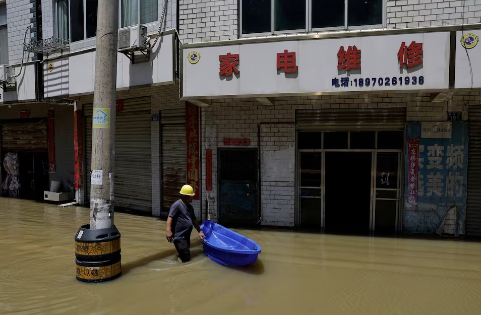
In July 2025, heavy rainfall killed at least 60 people across northern China, with flooding and landslides affecting Beijing and neighbouring Hebei province. In some areas, a year's worth of rain fell in less than a week.
Spire's soil moisture analysis of the July 2025 Miyun basin event documented how soils transitioned from drier-than-average to fully saturated in less than 48 hours as storms intensified over Beijing, producing flood inflows to the capital's primary reservoir at 6,550 cubic metres per second. Infrastructure designed for historical rainfall intensity was not equipped for what climate change is now producing.
The 2024 flood season had already set a concerning benchmark. China recorded its highest number of floods, with around 26 floods in major rivers across the country, affecting millions of people. The direct economic toll from these disasters reached 323.2 billion yuan, with southern areas experiencing harsher effects than the north.
In the first half of 2025 alone, 307 people were reportedly dead or missing and 620,000 faced emergency evacuation as a result of earthquakes, landslides, and flooding. Total economic losses reached 54.11 billion yuan. And those were pre-peak season figures.
Why Northern China Floods Are Structurally Different From Southern Ones
"The North Was Not Built to Handle This"
The 2026 warning's emphasis on northern China flooding is analytically important precisely because the north and south face different types of infrastructure vulnerability.
Southern China has experienced repeated major floods throughout its modern history. The Yangtze River basin flood management system, centred on the Three Gorges Dam, the South-North Water Transfer Project, and decades of levee reinforcement, while imperfect, is designed with flooding as its baseline condition.
Northern China's infrastructure was built around the opposite assumption: that water scarcity, not water surplus, was the governing risk. Urban drainage systems in Beijing, Tianjin, and northern Hebei were designed for historical precipitation averages that are now being routinely exceeded. When northern rivers flood, they flood into cities whose drains cannot process the volume.
Recent research published in npj Natural Hazards (February 2026) confirmed this structural shift, noting that climate change and human land-use decisions, particularly deforestation and polder expansion, have together altered China's flood regimes in ways that make extreme events "defy conventional hydrological expectations."
China has begun adapting. The China Meteorological Administration announced in January 2026 that it would pilot a new imminent warning system, apply artificial intelligence to refine typhoon and heavy rainfall forecasts, and develop new prediction products for extreme weather. The Ministry of Emergency Management says these measures have reduced flood-related deaths and missing persons by 54% compared to 2013 to 2017. But the economic losses from each event have risen, not fallen.
The Climate Driver: What Is Making 2026 Different
IPCC and CGTN Confirm the Pattern
The 2026 warning sits within a well-documented global pattern that climate scientists have been describing for years.
According to the Intergovernmental Panel on Climate Change, human-induced greenhouse gas emissions have led to an increase in both the frequency and intensity of some weather and climate extremes since pre-industrial times. Climate change is intensifying the water cycle, bringing more intense rainfall and associated flooding. As the climate warms, the most extreme rainfall events have become more frequent and intense across much of the world.
A 2025 climate report confirmed that June 2025 was 1.3 degrees Celsius above pre-industrial average, boosting Earth's moisture-carrying capacity and worsening the intensity of rainfall events when they do occur. This temperature-moisture relationship is why the same monsoon patterns that produced manageable floods in the 1990s now produce record-breaking inundation events.
What were once manageable seasonal rains now produce extreme precipitation events. Urban drainage systems designed for historical rainfall patterns struggle with these new intensities.
For China specifically, a study combining data from more than 1,000 hydrological stations found that decreases in river flow were mainly in northern China, driven by land use change. Simultaneously, increases in river flow were found in the south, driven by climate change. That divergence perfectly describes the 2026 warning: drought in some north and southwest areas, simultaneous flooding in the traditionally drier north due to changed storm patterns.
What This Means Beyond China's Borders
Food, Energy, and Global Supply Chain Risk
China's flood and drought events have direct global consequences that extend well beyond Chinese territory.
China is the world's largest producer of rice, wheat, and vegetables. A major Yangtze River basin flood during grain growing season, as occurred repeatedly in 2024 and 2025, reduces domestic production and increases Chinese demand in global commodity markets. A drought in Xinjiang affecting cotton and fruit production has immediate effects on textile supply chains in South and Southeast Asia.
The Songliao River basin flooding risk threatens China's soybean and corn production in Heilongjiang and Jilin, provinces that also supply feed grain to major livestock regions. Major flooding in these areas in June to August, as the 2026 warning indicates, would arrive during the critical growing season.
For global energy markets, Yangtze River water levels directly affect hydropower production across the Three Gorges Dam and the entire cascade of downstream installations. Low water levels from drought reduce power output. Extreme flooding forces spill releases that can both damage downstream infrastructure and temporarily destabilise power generation planning.
Conclusion: China Flood Drought Warning 2026 Is Not a Forecast. It Is a Pattern Confirmation.
The China flood drought warning 2026, issued by the Ministry of Water Resources on April 1, is the most geographically comprehensive extreme weather forecast the country has issued in recent memory. It covers simultaneous flooding and drought in different regions, typhoon path deviation into inland areas, and major flood risk in river basins that historically served as agricultural safety buffers.
This is not an unusual season badly forecast. It is the documented direction of travel for a country where climate change has already altered flood regimes, where the north is flooding in ways its infrastructure was never designed to handle, and where the economic losses from each successive flood season continue to rise even as the death toll, through better early warning, continues to fall.
The 2026 flood season began today. The warning was clear, specific, and grounded in two years of escalating precedent. The question for the months ahead is whether China's expanded forecasting systems, flood management infrastructure, and emergency response capacity can stay ahead of a climate that is moving faster than the defences built to contain it.


Comments (0)
Leave a Comment
No comments yet
Be the first to comment